As surely as spring follows winter, the coming change in season brings rising concern for flood-fearing residents of the B.C. Interior.
This year is no exception.
“We are seeing some fairly high numbers in specific areas…we’ve definitely got the readings right now that the mountain snow is a concern,” warns David Campbell, hydrologist & section head at the BC River Forecast Centre.
With early indications of far deeper than usual snow pillows across several mountain ranges, the question for Campbell and his team is how much is too much?
Campbell notes that while this winter started slowly with below normal precipitation, persistent storm systems through January changed everything:
“They are definitely starting to push up to the higher range provincewide,” says Campbell, while sharing the latest snow depth readings scheduled to be updated March 9.
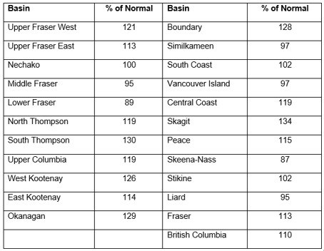
At last measure, the provincial average of snow measurements was 110% of normal. While Campbell has a reputation of not being an alarmist, he readily admits that increased flood risks are indeed developing in many regions, including the Upper Fraser – West, South Thompson, West Kootenay, Okanagan and Boundary, where mountain snowpacks were anywhere between 19% and 34% above normal.
“This is clearly shaping up to be a pattern that we’ve seen in the bigger years,” warns Campbell.
February 1, 2020 Snow Bulletin:

“Everything we can do in terms of emergency response is being done,” says Brian Taylor, the mayor of Grand Forks.
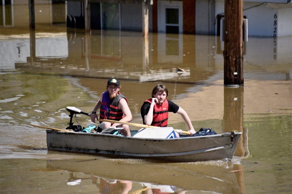
After being ravaged by serious flooding in 2017 and 2018, Taylor says his community is taking the early warning from the River Forecast Centre extremely seriously, and developing a new emergency plan. Taylor also stresses Grand Forks has learned from recent experience that flooding depends on both the snowpack and the weather:
“When it flooded here in ’17 and ’18, there was a weather pattern that crossed all of our watershed, the Kettle and Granby Rivers…and then the water came down at the same time and backed up where the two rivers met each other.”

Taylor laments that as his community prepares, they still haven’t recovered from their last disaster. Some North Ruckle residents who lost their homes in an area now designated as a floodplain have yet to be compensated by a $50 million federal/provincial flood mitigation program first announced last June.
“We’re working our hardest to get these folks in North Ruckle the most they can get for their property,” vows Taylor.
“I don’t think it is ever too early,” says Campbell when asked whether spring flooding concerns are premature. While two-thirds of the annual snow accumulation has typically occurred by February 1st, Campbell stresses that snow depth is only one part of the flood threat equation, convinced that spring weather will hold the key.
How warm, how soon, how wet? Only time will tell. It always does.
As always, I welcome your comments and criticism on Twitter @kammornanchor and email [email protected].
Bob Price is a veteran B.C. broadcaster who anchored the morning news on CHNL radio in Kamloops for the past 30 years. Bob is also a past Webster Award winner whose previous stops included Vancouver and Calgary.
SWIM ON:
- In May 2019, Bob Price wrote about parched pastures and weather worries for BC ranchers.
- Jody Vance: In the event of a major weather event, natural disaster, or (cough) extended rail and infrastructure shutdown, how long will your pantry last?
- It's never too late for New Year's Resolutions to boost your business.


