It has been a calamitous year for British Columbians.
The Heat Dome brought destruction with the wildfire infernos just a few months ago, and now the great British Columbia deluge of 2021 – and all this through a pandemic!
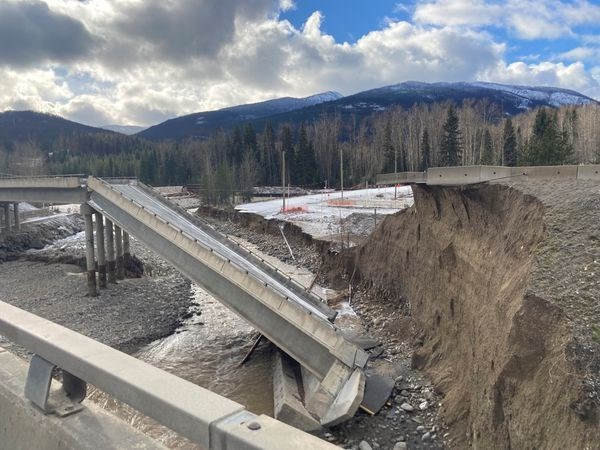
We prayed for rain and received it in massive abundance, much of our transportation infrastructure has been destroyed, supply lines further stressed and this last “atmospheric river” that so inundated BC (with apparently more to follow) is responsible for yet another declaration of emergency.
While we have been severed from the rest of Canada by both road and rail – this is not the first time this has happened.
As I sit here writing, after a self-imposed exile to the family farm since the disastrous wildfire season I reported on last summer, I have become something of a backwoods historian, hiding out in nature, with much time to reflect on the loss and hardship I witnessed the last time the Coquihalla Highway was shut down.
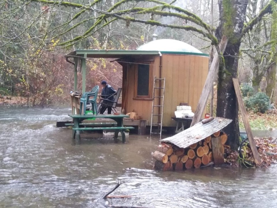
Just three months ago. two massive fires merged to engulf this essential transportation corridor. I remember it well; I was in Merritt, and the only escape route was via Princeton. Look at these two towns now, drenched and submerged, in desperate need of help. After the summer inferno reduced Lytton to ashes, the massive floods and slides we have just experienced throughout southern BC has left me quite gobsmacked, spurring me to investigate, especially as my writing shack here on Vancouver Island was almost swept away.
British Columbia is a province not particularly advantaged when it comes to agriculture. Its mountainous geography encompasses over 900,000 square kilometers, but only a miniscule three percent is potentially arable.
While Interior BC endures harsh winters and the effects of increasing drought, comparatively, the Lower Fraser Valley has a much gentler climate and plenty of rain – particularly in 2021. At the same time, historically, the single greatest disadvantage of the lower Fraser has been the annual flooding that occurred normally each summer. Early gold seekers soon discovered how the Fraser River can climb in height, their early gold claims submerged.
As early as 1860, Governor James Douglas encouraged the expansion of farm settlement in the Lower Fraser Valley, but apparently few were interested due to the unpredictable threat of flooding. Of course, the original attraction of those who came was for gold – not land.
Douglas was well aware that the fertile lands of the Lower Fraser River were “exposed to overflow during the periodical inundations of the Fraser.” Douglas, with his usual foresight, recorded further observations just as applicable to our current state of emergency – especially with regard to supply chains and food self-sufficiency.
Douglas wrote that "the durable prosperity and substantial wealth of states is . . . derived from the soil. Without the farmer's aid British Columbia must remain forever a desert, to be drained of its wealth and dependent on other countries for its daily food."
With the farms of the Sumas Prairie having been inundated (a region that apparently accounts for about half of the province’s production in poultry and eggs, among other foodstuffs), the first BC governor’s words from over 160 years ago still have relevance to today.
Small-scale diking was apparently first tried in 1864 by a farmer in Delta. That success led others to dyke their own farms along the lower Fraser River, including “Honest” John Oliver, later BC Premier, 1918-1927. From Douglas’s time, the threat of flooding essentially precluded serious large-scale land reclamation for the next 30 or so years, until larger-scale dikes, drainage channels, pumps, and gates provided the infrastructure that reclaimed some of the province’s most fertile agricultural land.
With the coming of the Canadian Pacific Railway and rapid growth of the new City of Vancouver (1886), local food production was essential. In fact, since the 1858 gold rush, BC always had to contend with importing California produce to meet shortages, compounded by the great paucity of land suitable for agriculture. Vancouver was largely hemmed in by steep rocky slopes and great forest lands – not great land for farming. Hence, draining and diking in the Lower Fraser Valley was deemed an obvious and essential solution.
In the history of our province there have been two earlier great floods that wreaked similar damage to what we are witnessing today: both were during the period of greater land reclamation in 1894 and 1948.
In one of the great tragedies of BC engineering, the first large-scale dikes of the late 19th century, employing coal-fired steam engine pumps, were constructed and completed by 1894 – only to be hit hard by a devastating flood.
They had been built two feet higher than the previous record water height of 1882, but this was simply not enough; they were soon breached. Devastation was quick. But perhaps more importantly, the level of debt incurred to build, and subsequently rebuild, these early land reclamation works, though substantial, was never enough to fully counter the unpredictable flooding of the Fraser River.
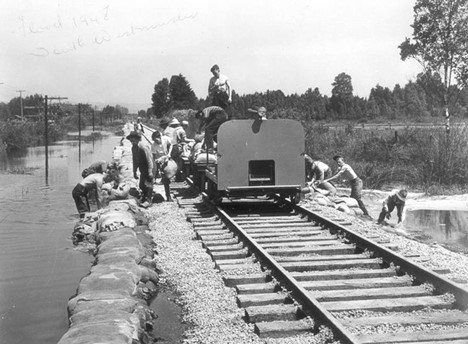
And so it was in 1948 when the Fraser eclipsed the water level of 1894, broke the dikes once more, flooding the Lower Fraser Valley again, and prompting – for the first time ever – the intervention of the federal government, which offered substantial financial aid to BC to invest in better diking and drainage.
After 1894, dikes had been again heightened by a further two feet. I wonder, with climate change, will this be our solution again: keep building taller dikes?
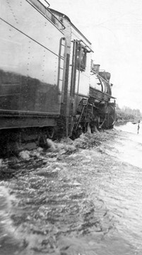
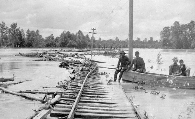
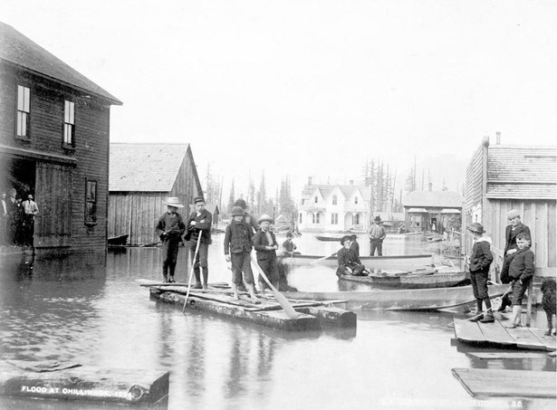
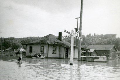
Like today, in 1948, all road and rail transportation to the rest of Canada was halted due to submerged highways and damaged train tracks. But unlike 1894, Vancouver was now a significantly larger port, Canada’s Western entrepot on the Pacific. Canada could simply not afford to have their communication with BC remain broken.
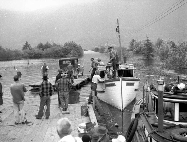
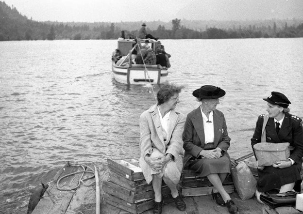
The Royal Canadian Navy was given command of the Lower Fraser River, with the power to requisition boats to rescue those stranded. By March 31st, the provincial government announced a state of emergency and the Army took charge of all dikes. From that point on, the federal government became involved in all future land reclamation projects in the province. The federal government of Prime Minister Mackenzie King also pledged $5 million in disaster relief, in addition to agreeing to pay 75 percent of all reconstruction of the dikes and drainage channels that had been destroyed: “Dikes are not the concern of the people living behind them alone, but are also of vital interest to the nation.”
Just as in 2021, the great deluge of 1948 had broken all links with the rest of Canada. More than 2,300 homes were destroyed, and the number of evacuees exceeded 16,000 people, along with extensive crops and livestock lost.
Perhaps this time Canada, in securing its national interest, might go one further. Let’s not just secure and improve existing dikes. Canada should reasonably pay for a new one that will effectively impede the rising waters of the Nooksack River (north of Bellingham) in neighbouring Washington State. The spilling of additional waters from across the border has been a major contributing factor in the flooding of Sumas Prairie. A dike along the 49th parallel? Now that would be something!
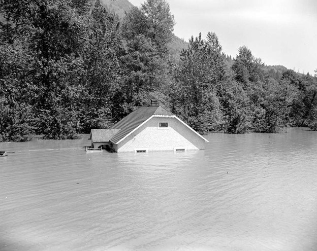
And there is perhaps greater incentive to do so if the projections of climate change are taken seriously. Because the one main difference between the great floods of 1894 and 1948 and the great deluge of 2021 is this: previously, floods have occurred with the usual Spring melt. In our case, the great British Columbian deluge of 2021 has occurred in November, winter has just begun, and the immense flooding is squarely attributable to massive rainfall – one month’s worth of rainfall in just two days, which we now know is called an atmospheric river.
To my mind, extraordinary times call for extraordinary measures.
Author’s note: Invaluable historical information for this article comes from “The Reclamation of Pitt Meadows” by John Eric Collins, MA Thesis (1975)
A fifth-generation British Columbian, Daniel Marshall is an author, professor, curator, documentarian, and researcher focusing on British Columbia’s relatively untold but rich history. He is a recognized leader and award-winning researcher on historic Native-Newcomer relations, and their evolution and implications on Aboriginal rights today.
His award-winning documentary, Canyon War: The Untold Story, has aired on Knowledge Network, APTN, and PBS. His latest book, Claiming the Land: British Columbia and the Making of a New El Dorado, is available in bookstores across B.C.
Claiming the Land has achieved a rare and possibly unique feat in BC History by winning three major book awards: the Canadian Historical Association’s 2019 CLIO PRIZE for best book on B.C.; the 2019 Basil-Stuart-Stubbs Prize for outstanding scholarly book on British Columbia, administered by UBC Library; and the 2019 New York-based Independent Publishers’ Book Award (Gold Medal for Western Canada).


